
Top 10 Bend Oregon Hikes!
1. Tumalo Falls–

Bend Oregon’s beautiful Tumalo Falls in summer with a foreground of wildflowers.
Tumalo Falls is one of Bend Oregon’s most iconic landmarks. This beautiful 100 foot waterfall is located about 14 miles west of downtown Bend, at the end of Skyliners road.
The primary parking area for Tumalo Falls is about 200 feet from Tumalo’s lower viewpoint, making it accessible to all. By turning left prior to the lower viewpoint and hiking uphill for 1/4 mile, you can enjoy the upper viewpoint which offers views of the falls from above as well as the Tumalo Creek Canyon.
Hiking options abound in the Tumalo Falls area but I prefer a 7 mile loop hike which parallels Tumalo Creek for the first 3.5 miles and passes 10 more waterfalls in that span before the loop hike takes a left turn on the Swampy Lakes Trail. Hikers will stay on the Swampy Lakes Trail until it intersects the Bridge Creek Trail where you should take another left and follow the Bridge Creek Trail back to the Tumalo Falls parking lot.
Know before you go!
-The Tumalo Falls area is beautiful and that is no secret, which means that it gets crowded. Go early or on weekdays to avoid crowds and overflowing parking lots
-A $5 daily or $35 annual Northwest Parking pass are required for parking in the Tumalo Falls parking lot.
-If you choose to hike the 7 mile Tumalo Falls to Bridge Creek hike, You will enter the Bend Oregon watershed when you reach Bridge Creek and Dogs are NOT Allowed in the Bend Oregon watershed. To avoid the dog free zone, simply do an out and back route and turn around when you reach the junction of the North Fork Trail and the Smampy Lakes Trail.
2. Sparks Lake-
 Sparks Lake Sunrise, near Bend, Oregon.Beautiful Sparks Lake offers one of the most stunning views in all of Oregon. Sparks is a slice of heaven for landscape photographers like myself as well as hikers and water sports aficionados. My fine art landscape photograph, Sparks Lake Sunrise typifies how beautiful this lake with its views of South Sister and Broken Top Mountain as well as Mt Bachelor can be.
The Sparks Lake Parking area is located 27 miles from Bend, on the Cascade Lakes National Scenic Byway.
The hike at Sparks Lake is a short 2.5 mile scenic loop on the Ray Atkeson Memorial Trail. The trail is paved for the first 1/4 miles at which point there is a stunning view of South Sister and Broken Top over the waters of Sparks Lake. Beyond this initial viewpoint, the trail is unpaved but the trail remains flat and family friendly. The trail forms a figure 8 loop which offers a shortcut back to the parking lot potentially shortening the trail to 1.25 miles. The loop is highlighted by interesting volcanic formation and stunning mountain views!
Know before you go!-
-Much like Tumalo Falls, Sparks Lake is a beautiful place, making it a very popular place. Do not expect to find solitude on summer weekends.
-weather is fickle in the Oregon Cascades during shoulder seasons it is wise to to bring an extra layer of clothing and to check the weather forecast before leaving home.
-A $5 daily or $35 annual Northwest Parking pass are required for parking in the Tumalo Falls parking lot.
-Dogs must be on a leash on this trail
3.Pilot Butte

Rising 500 feet above the high desert, Pilot Butte State Scenic Viewpoint is an ancient extinct volcano right inside the city of Bend, Oregon. This 4,136-foot landmark offers an easy escape for epic 360-degree views of the Cascade Mountains and the town below. visible mountains include Mt Bachelor, the Three Sisters, Broken Top, Mt Jefferson and Mt Hood.
The hike to the top of Pilot Butte is approximately 2 miles, round trip and circles the 188,000 thousand year old volcano. The stunning views from the top are arguable the best in the city of Bend. For those who are pressed for time, there is a road to the top of Pilot Butte which can get quite crowded during summer evenings. The road is open from sunrise to sunset from mid April until the end of October. HIking trails are always open but can be quite treacherous in winter.
With nearly 1,000,000 million visitors per year, Pilot Butte is on of the most visited Oregon State Parks east of the Cascade Crest.
Know before you go!-
-Pilot Butte is free!
-Dogs must be on leashes at all times
-Water fountains and bathrooms are available at both the base and the summit of Pilot Butte
4. Broken Top Mountain
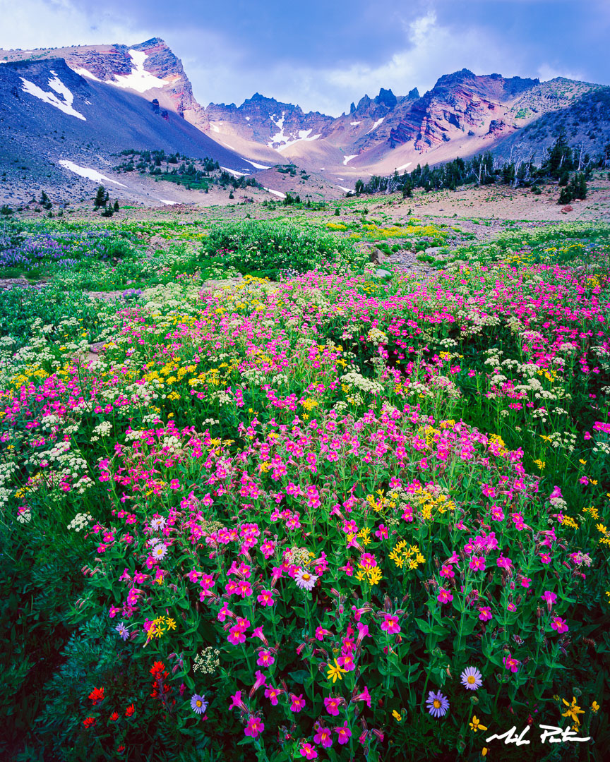
Broken Top Eruption, Wildflowers explode on Central Oregon’s Broken Top Mountain
The alpine hike to No Name Lake on Broken Top Mountain in Oregon’s Three Sisters Wilderness covers approximately 6 miles round trip with an elevation gain of nearly 1,500 feet. This stunning trail rewards hikers with the icy turquoise waters of No Name Lake which is located inside a dramatic volcanic crater.
The journey begins under a cool tree canopy before breaking out into wide, exposed alpine slopes. You will follow trickling snowmelt streams and pass vibrant summer wildflowers. Past the trail junction, the grade steepens as you navigate loose volcanic gravel and occasional snowfields. Cresting the final ridge reveals No Name Lake—locally called Todd Lake’s wild sibling—nestled directly at the base of Broken Top’s jagged, snow-streaked peaks.
This alpine hike is graced with several wildflower laden streams and in both the Broken Top Crater as well as the No Name Lake Basin. It’s important to note that the rim above the west side of No Name Lake offers stellar views of the Three Sisters. The lake itself is an impossible color of blue which is a result of silt formed by glaciers grinding rock into powder which is suspended in the lake’s water and absorbs shorter wavelengths of light and allows blue and green wavelengths to be reflected.

“Alpine Bliss”, Broken Top Mountain and N0-Name Lake, Three Sisters Wilderness, Oregon
Know Before you go!-
-Central Cascades Wilderness Permits: Required for day use and overnight stays from June 15 through October 15, bookable via Recreation.gov.
-Parking: Requires a Northwest Forest Pass or interagency equivalent outside of permit dates.
-Dogs: Allowed on a leash from July 15 through September 15 (prohibited or restricted outside these dates for wildlife protection).
5. Green Lakes

The Three Sisters and Green Lakes Basin, near Bend, Oregon
The Green Lakes Trail in the is a 9.5 mile round-trip hike with a 1,150 foot elevation gain. Located 30 minutes west of Bend, Oregon, this popular route climbs past Fall Creek waterfalls and obsidian lava flows to turquoise alpine lakes nestled beneath South Sister and Broken Top.
Hikers will enjoy several prominent waterfalls which can be lined by golden riparian bushes in autumn.
At the turn around point, the route enters a wide basin holding three vivid, emerald-green alpine pools. Towering views of the snow-capped South Sister and the jagged crags of Broken Top frame the water.
Know Before you go!
-Parking Pass: A Northwest Forest Pass is required at the trailhead.
-Permits: A Central Cascades Wilderness Permit is required for day use and overnight camping from June 15 to October 15.
-Pets: Dogs must remain on a leash during the peak summer and early fall seasons.
6. Todd Lake

Indian Paintbrush bloom in the meadows surrounding Todd Lake with Mt Bachelor in the background
Nestled at an elevation of 6,150 feet along the Cascade Lakes Scenic Byway, the Todd Lake Loop is a gentle, family-friendly 1.7-mile trail that circles a 45-acre alpine lake in the Three Sisters Wilderness. It offers flat terrain, stunning mountain views, and rich wildlife viewing just a short drive from Bend, Oregon.
This wonderful lollipop loop hike can be done in either direction. Hikers will enjoy mirrored reflections of Mt Bachelor as well as distant views of Broken Top Mountain. At the peak of wildflower season, the meadows at the west end of the lake are filled with Indian paintbrush, Jeffrey’s shooting star and buttercups.
Know Before you go!
-Lake Loop: Walking around Todd Lake does not require a wilderness permit, though a recreation pass is needed for parking at the Todd Lake Trailhead.
-Wilderness Extensions: Connecting to longer routes like the Soda Creek or Broken Top trails requires a Central Cascades Wilderness Permit during the peak season.
-Access: The bumpy, unpaved access road works best for vehicles with decent ground clearance.
7. Tam McArthur Rim

Sunset over Central Oregon’s Tam McArthur Rim
The Tam McArthur Rim hike isa 5.4 mile round trip adventure in the magical Three Sisters Wilderness with 1,250 feet of elevation gain. It starts at Three Creek Lake, climbs dusty switchbacks through pine forests, and opens to grand views of Broken Top and the The Three Sisters, Mt Jefferson and Mt Hood.
The path begins near Three Creek Lake. It climbs right away under a canopy of older pine trees. You walk up steady, dusty switchbacks. The trees start to thin out as you reach the subalpine zone.
The trail pops out on top of the rim. You get huge views of Three Creek Lake far below and the sharp peaks of Broken Top and the Three Sisters ahead.
Know Before You Go!
-Parking Pass: A Northwest Forest Pass is required at the trailhead.
-Permits: A Central Cascades Wilderness Permit is required for day use and overnight camping from June 15 to October 15.
-Pets: Dogs must remain on a leash during the peak summer and early fall seasons.
8. Metolius River

Autumn Rush, Metolius River
The West Metolius River Trail is a scenic, 5.4-mile out-and-back trail in Deschutes National Forest near Camp Sherman, Oregon. This easy, dog-friendly route features an elevation gain of 265 feet and meanders alongside the vivid turquoise waters of the spring-fed Metolius River.
Starting at the Lower Canyon Creek Campground, this beautiful trail passes beneath towering Ponderosa Pines, Douglas Firs and Incense Cedars with an understory of vine maples which turn vibrants hues of orange and yellow in autumn.
Not far from the trailhead, the trail passes the mesmerizing “Gushing Springs” whose crystal clear water burst directly out of a mossy hillside into the Metolius.
At the halfway point of the hike, stop at the historic Wizard Falls Fish Hatchery to view pools of enormous rainbow trout.
Know Before You Go!
-Terrain: Mostly flat, soft-surface singletrack with gentle inclines and minor rocky patches.
-Access Points: Can be started from Lower Canyon Creek Campground or the Wizard Falls Fish Hatchery.
-Rules: Free to access with no permits required for day hiking, though dogs must remain on a leash.
9 Smith Rock State Park

Sunrise illuminates the vertical spires of Oregon’s Smith Rock State Park in the midst of winter fog
The iconic Misery Ridge Trail at Smith Rock State Park near the Central Oregon town of Terrebonne is a strenuous 4 mile loop featuring roughly 1000 feet of elevation gain. Famous for its relentless, steep climb up volcanic tuff, it rewards hikers with sweeping views of the Cascade Range and the winding Crooked River.
Know before you go!
-Parking Pass: A $5 parking fee is required unless you have an annual Oregon State Parks Pass.
-Pets: Dogs must remain on a leash during the peak summer and early fall seasons.
-Water: This hike is relatively hard, there is very little shade and there is no potable water along the way, so bring lots of water.
10 Deschutes River Trail

Dillon Falls in Autumn, Deschutes River Trail, near Bend Oregon
Hiking the Deschutes River Trail near Bend, Oregon in the Deschutes National Forest offers an 8.5 mile one way journey past towering Ponderosa Pines, ancient lava flows and roaring waterfalls. This scenic path runs from the meadow day use area upstream towards Sunriver.
There are countless out and back options with developed parking areas with some facilities at Meadow Camp, Lava Island, Big Eddy, Aspen Camp, Dillon Falls and Benham Falls. The Deschutes River Trail can also be hiked in either direction with equal enjoyment.
Trail Highlights
- Dillon Falls: Watch churning white water rush through a tight volcanic rock canyon.
- Benham Falls: See the wide river break into powerful, rushing cascades.
- Lava Rock Formations: Walk next to rough, black basalt flows left by old eruptions.
- Pine Forests: Enjoy sweet-smelling ponderosa pine and sturdy juniper trees along the path.
Know Before You go!
- Distance: Up to 17 miles round-trip, but easy to shorten using multiple roadside trailheads.
- Terrain: Mostly flat dirt paths with some uneven, rocky sections.
- Fees: A $5 daily Forest Service fee or an annual recreation pass is required at trailheads.
- Dogs: Allowed, but must be kept on a leash from May 15 to September 15.


